Services
Builder's Package
For single lot housing or rural estate lot development, this package is designed for the homeowner or small to medium builder.
Services include:
- Land Registry office Title Search
- Survey of a subject lot to establish boundary limits and locate topographic features
- Preparation of the Site Grading and Services Plan
- Calculations to site the new building on the subject property
- Stakeout building perimeter for excavation
- Set footing footprint after excavation
- Final Survey of completed foundation in relation to boundaries
- Set lot grading stakes
Construction Layout
From our own topographic and boundary surveys or customer information, we will lay out the building envelope, grid lines, and elevations. If requested, footing pins, nails in the footings to aid wall forming, final surveys, top of finished wall and finished slab elevations, and final grading can also be done. All services listed here can be combined into the builder's package.
Reference Plans
A reference plan is a registered public document deposited in a Land Registry Office.
As its name suggests, it is a graphical representation of a metes and bounds description (the words used to describe the subject property in a deed).
It is also a representation of divisions of land under the planning act.
Reference plans show boundaries as well as any physical or documentary evidence that affect the title to a properety.
A reference plan has many uses:
- Simplifying an otherwise confusing deed
- The first step in land titles conversion
- Severing a property
- The property descriptor itself for Townhomes
Boundary Surveys
This service identifies the original property boundaries as well as highlighting any encroachments or encumbrances on the land or title. This is used for the purposes of properly locating new buildings and boundary fences.
A Boundary Retracement Survey usually requires fieldwork on the subject and neighboring lands to verify or find existing monumentation.
Extra research and field work to determine the property lines may be required.
The corners should be marked in accordance with the standards.
Area Certificates
We provide a dimensioned sketch along with an area certificate for lease purposes.
Measuring the building for the area would be performed after the exterior is substantially completed.
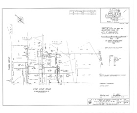
Site Grading Plans
Site grading plans are based on existing ground conditions.
In consultation with the customer and various zoning and bylaw agencies, the surveyor develops a plan to show the subject property along with any structures also being proposed.
Included on the plan are the proposed finished grades, structure elevations, services, and streets.
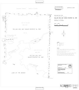
Canada Lands Surveys

Only a Surveyor with the Canada Lands Surveyor designation is licensed to survey lands in Canada that are under Federal jurisdiction.
Examples of Federal Land are:
- Aboriginal Territories
- Federal Territorial areas
- DND properties
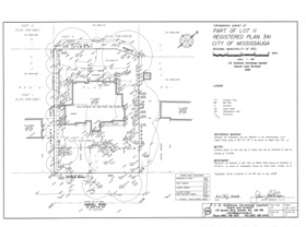
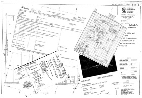
Surveyor's Real Property Report
A Surveyor's Real Property Report must be prepared by a licensed Ontario Land Surveyor.
A SRPR is prepared specifically to illustrate the location of buildings or structures relative to the boundaries of a unit of land. It also shows the location of any other physical features and registered encumbrances, such as easements, on or immediately adjacent to the property.
In a Real Estate transaction, a current Surveyor's Real Property Report provides all parties to the transaction with a precise representation of the property prior to the purchase being completed.
“Good boundaries make good neighbors!”
Topographic Surveys
Topographic surveys are plans that show the physical properties of a site.
These plans may be used by Engineers and Planners to assist with the design of a development proposal.
It shows the physical constraints that the proponent must consider in a development application, or a detailed design of a site for development purposes.
The surveyor often provides the topographic plan, which shows vertical elevations or contours, and physical details of the subject lot above, on, and below the ground.
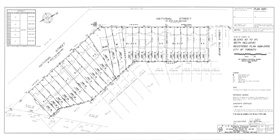
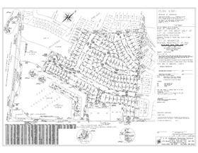
Subdivisions
Subdivision plan according to the Planning Act is one of the ways to divide a tract of land into several building lots or blocks, in order to sell one or more.
Draft Plan of Subdivision
A draft plan of subdivision is a proposal to subdivide property. It generally shows topographic information, natural heritage features, such as creeks and vegetation, and the proposed lots and streets.
Monumentation
After the approval of the draft plan and before the registration of the subdivision plan monuments defining the corners and limits of the proposed lots or blocks must be set.
Plans of Subdivision
A plan of subdivision must be surveyed by a licensed Ontario Land Surveyor.
Upon registration in the Land Registry Office, after appropriate approvals have been obtained, a registered plan of subdivision becomes a legal document that implements an approved draft plan of subdivision. A registered plan of subdivision shows:
- The exact extent and survey boundaries of lots on which houses or buildings are to be built
- The location, width and names of streets
- Blocks of land for other community purposes, such as schools or parks.
Research
Knowledge is the key to success.
The decision to develop, purchase, or transfer a parcel of land is an important one.
The background research into the title is often quite revealing. Zoning restrictions, service easements, rights of way, and restrictive covenants that may not be declared by a vendor or agent can often be a roadblock to a new intended use.
JHG Surveying has the knowledge, experience, and skill to research the history and current conditions of a parcel of land in order to assist the owner, or potential owner, in making a decision regarding a course of action for their property.
Severances
A land severance (separating one piece of land into 2 or more pieces) starts with a severance (or separation) sketch.
This sketch, while not a formal plan of survey, is a legal document based on field measurements, and is prepared to illustrate the intent of the land severance.
Once the proposed severance is accepted, a Reference plan is prepared and deposited on title at a Land Registry Office.
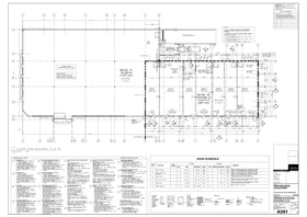
Engineering Services
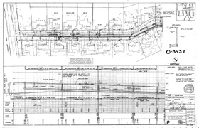
From our initial site surveys, architects and engineers detailed design and layout drawings, we are able return to site while construction is in progress to control elevation, horizontal position, dimensions, and configuration.
Some of the uses of this type of plan include:
- Setting out (lines and grade for buildings, fences, roads, etc.)
- Survey control
- Precise monitoring of geographic features
- Utility layout
- Layout of municipal services
- Layout of rail lines
Condominiums
Condominium Plans must be prepared by a licensed Ontario Land Surveyor.
A Condominium Plan is also a plan of subdivision, which creates new parcels of land called Units. The major difference is that, except in the case of a vacant land condominium, the units are three-dimensional, with the boundaries being the physical surfaces of the buildings themselves. Since units may be located above and below each other, the legal description of the parcel must specify the Unit Number, Level Number, and Plan Number.
Unit owners share the ownership and the cost of maintaining the parts of the condominium that are not units.
Types of Condominium:
- Freehold condominium corporation
- Common elements condominium corporation
- Phased condominium corporation
- Vacant land condominium corporation
- Standard condominium corporation
- Leasehold condominium corporation
Common Element Condominium Corporations
No residential units are created; the developer can sell shares in a recreational facility to owners of properties within the same land registry division in which the condominium is registered.
The mainly common model currently is a freehold townhouse project with the internal roadways and walkways (including their maintenance and outdoor lighting) as well as any recreational facilities being condominiumized.
Phased Condominium Corporations
Instead of a different condo corporation being created in a three-tower (3 phased) condo project (for each condo tower as it is being built), the developer can establish a condo corporation, which has the ability to add each phase to the originally registered condominium corporation as each phase is completed. The benefits will be to avoid a lot of unnecessary expense flowing from creating different corporations for each phase of the same project with different management companies, reciprocal agreements, easements, etc. In order to take advantage of this concept, all phases must be completed within a 10 year period.
Vacant Land Condominium Corporations
The units will be vacant lots although common elements can be (for example) a clubhouse, golf course, or recreational facilities. The builder can establish restrictions regulating the type of housing to be built on the lots.
Leasehold Condominium Corporations
An institution (for example) with excess land can establish a lease term of between 40 and 99 years (must be the same term for all units being built in the project) so that unit owners will own a leasehold right for a certain period with such leasehold right being capable of mortgaging, selling, etc. At least five years before the lease term expires, there must be a written notice by the lessor regarding a lease renewal; a lease renewal must be for a minimum of ten years.